Geography & Demographics
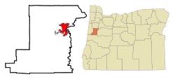
Corvallis is located in central western Oregon, United States. It is the county seat of Benton County and the principal city of the Corvallis, Oregon Metropolitan Statistical Area, which encompasses all of Benton County.
Situated midway in the Willamette Valley, Corvallis is about 85 miles (137 km) south of Portland, 30 miles (48 km) south of the state capital, Salem, ten miles (16 km) southwest of Albany, about ten miles (16 km) west of Interstate 5 at its closest point, and 44 miles (71 km) north of Eugene / Springfield. By car, the travel time is about an hour and a half from Portland, and 45 minutes to an hour from Eugene/Springfield, taking I-5. Oregon Route 99W, a secondary north-south route, also runs through Corvallis.
Founded/Incorporated: 1845 / 1857
Motto: Enhancing Community Livability
Coordinates: 44°34'14.81?N 123°16'33.59?W
County: Benton
Total Area: 14.43 sq mi (37.37 km2)
Land Area: 14.23 sq mi (36.86 km2)
Water Area: 0.2 sq mi (0.4 km2)
Elevation: 235 ft (68.28 m)
Time zone: PST (UTC-8), PDT (UTC-7)
Area code: 541
Demographics and Census Data
Corvallis is the largest principal city of the Albany-Corvallis-Lebanon CSA, a Combined Statistical Area that includes the Corvallis metropolitan area (Benton County) and the Albany-Lebanon micropopulation area (Linn County).
Select demographic statistics are provided here. More comprehensive demographic information can be found on the Census Reporter web page for Corvallis, OR.