9th Street Pedestrian Crossing Project

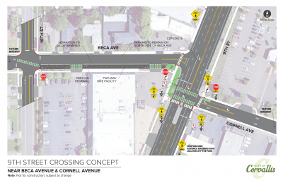
The 9th Street Pedestrian Crossing Project is identified as a High Priority (Project P3) in the City's Transportation System Plan and was included by Council in the City’s adopted Capital Improvement Program (CIP). This project will construct an enhanced pedestrian crossing at the intersection of 9th Street and NW Cornell Avenue. The crossing will feature a concrete pedestrian island controlled by Rectangular Rapid Flashing Beacons (RRFBs), similar to other crossings along 9th Street. The island will span from the north side of NW Beca Avenue to roughly 70 feet past NW Cornell Avenue. These extended portions will restrict left turns out of both Beca and Cornell Avenues, increasing safety for all road users.
In parallel to this project the City has been developing a Transportation Safety Action Plan through the Safe Street and Roads for All (SS4A) project. This plan has included a review of crashes and risk throughout the community and revealed that a major source of crashes on the 9th Street corridor involved turns.
Also featured will be a short two-way protected bicycle lane connection that allows people to ride, in both directions, on the south side of Beca and Cornell Avenues. This treatment points people, traveling in either direction, to cross 9th Street at the enhanced crossing.
Answers to questions about this location and crossing concept are further below.
How We Got Here
City staff identified several potential locations for the crossing and asked for input from the community through a questionnaire in late 2024. A map of the crossing location options can be found here. Staff also developed a matrix showing how each location performs against several important considerations. The matrix is available here.
In spring and summer 2025, City staff considered the community feedback previously received along with technical analysis and selected the crossing location that is described and linked above. View a larger version of the conceptual design. The project timeline and answers to questions about the proposed concept are below.
Project Timeline
Fall 2024: Community questionnaire
Winter 2024: Technical analysis and crossing location selection
Fall 2025: Crossing concept shared and additional public outreach
TBD: Final design and construction
Frequently Asked Questions:
Q: Why is an enhanced crossing needed between Grant Avenue and Buchanan Avenue? Shouldn’t people cross at existing traffic signals?
A: Currently, there is a long distance between signalized crossings (over 1,500 feet or ¼ of a mile). Crossing this busy 5-lane section of 9th street is a barrier to travel without some sort of enhancement. This area has a high demand for crossing due to the density of businesses and destinations on both sides of 9th Street. Additionally, the multi-year effort to update the City’s Transportation System Plan that included significant community-wide public engagement prioritized a crossing in this area. Further, Council has prioritized and funded this as a project within the City’s budget and near-term multi-year Capital Improvement Program.
Q: What are the safety benefits of an enhanced crossing with a rapid flashing beacon?
A: Benefits include:
- Increases visibility of the crossing and alerts drivers when a people walking and bicycling want to cross
- Numerous studies have shown that these treatments can, and do, significantly increase yielding by drivers to people attempting to cross, especially wider and busier streets like 9th Street
- Provides traffic calming and reducing driver speeds by visually and physically narrowing the road
- Provides a refuge island so that people walking and bicycling only need to cross one direction of traffic at a time
Q: I have seen crossings and medians damaged by being struck by vehicles. I am concerned this means these facilities on 9th and elsewhere are “unsafe”. Are they truly safe?
A: Yes, these facilities are well documented to improve safety for people crossing. National research has shown that they can reduce pedestrian crashes up to 47%. Occasional minor property damage to traffic equipment and vehicles, that often occurs at nighttime in the form of drivers leaving the scene with no one crossing present, does not mean the crossings themselves are unsafe.
Q: What location was selected and why?
A: After weighing the options in the corridor, trade-offs (such as impacts to access), and the community questionnaire feedback, the south side of 9th Street and Cornell Avenue was selected.
Why:
- The location is roughly halfway between existing signalized crossings at Grant and Buchanan Avenues.
- Observed existing crossing activity and likely unseen demand due to surrounding land uses (e.g. Goodwill, Natural Grocers, etc.) along with connectivity to the neighborhood (Beca Avenue runs continuously to the east for more than 0.7 miles)
- This location can be constructed with median island designs like those found at 9th Street and Spruce Avenue (further north) so that it preserves business access and keeps the left turn open into Cornell Avenue from southbound 9th Street.
- Median island design can also be used to help mitigate the current conflict that exists in the center turn lane on 9th Street due to the short distance between the closely spaced offset intersections at Beca and Cornell.
- This location is the most direct connection for the future Beca Avenue Neighborhood Bikeway from the City’s Transportation System Plan and its connection to the shared use path under and adjacent to Highway OR 99W on the east end of Cornell.
Q: How would this location and the proposed improvements change or impact street and business access?
A:
Cornell Avenue:
- All turns into Cornell will be maintained.
- Left turns out of Cornell will be prohibited, meaning traffic exiting Cornell must turn right, including City of Corvallis Public Works. This is similar to the intersection of 9th and Spruce further north, close to Circle.
- The FedEx driveway on 9th will likely become right-in and right-out only due to median placement, but as described above, the business’ secondary driveway on Cornell can still be accessed through both left and right turns into Cornell from 9th.
Beca Avenue:
- Right turns in and out of Beca will be maintained.
- Left turns in and out of Beca will be prohibited, but driveway access to the adjacent shopping center will be unaffected.
There may be other driveway access changes (such as right-in/right-out) that are refined during final design, but the above is what is anticipated at the current conceptual stage for the project and this location.
Q: Will street lighting be addressed in this project?
A: During final design, illumination for this location will be analyzed to determine if changes to existing street lighting are needed for the crossing.
| Ted Reese | Transportation Engineering Supervisor | 541-766-6916 | ted.reese@corvallisoregon.gov |